Internal truck/IGV positioning
1. Feature introduction
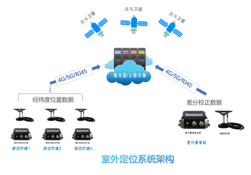
The internal container truck positioning provides integrated high-precision positioning services for the port area, and can achieve centimeter-level positioning by obtaining the differential data of the port's proprietary services, and the terminal has the function of inertial navigation integration and vehicle status acquisition, and transmits the positioning data back to the monitoring center in real time, which is used to support the background location-based business system. The backhaul data includes: latitude and longitude, speed, time, heading, ID, etc.

2. Technical indicators
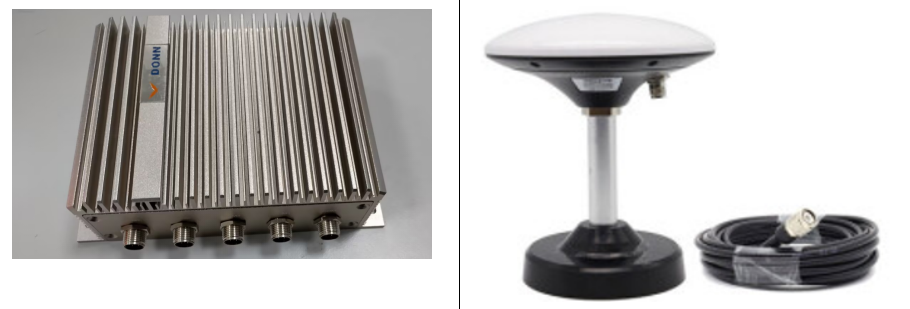
(1)The GNSS fusion positioning terminal is installed in the cab and can be connected with the on-board computer of the internal container truck, and the GNSS antenna connected to it is fixed on the roof of the vehicle, which can achieve centimeter-level positioning accuracy and achieve stable positioning of less than 10 cm in most areas of the dock yard
(2)According to the accuracy and validity of the satellite positioning data, the real-time data of the position, speed and heading of the internal container truck obtained by the mobile station can be directly sent to the TOS, and can also be compared with the operation task locally to trigger the relevant operation task
(3)The system receives the position coordinates in real time through the GNSS antenna, and verifies them through the differential data of the base station. Through 4G network and other communication methods of data transmission, the GNSS module transmits real-time positioning data to the back-end system, so as to provide accurate vehicle position data to the back-end system
(4)The high-precision positioning system jointly built by the vehicle terminal, the base station and the software platform has a maximum error of less than 10 cm in the positioning data of the container truck and less than 1 meter in various application scenarios of the port

3. System features
(1)The vehicle-mounted terminal positioning system consists of a vehicle-mounted positioning and identification all-in-one machine with an internal container card and a GNSS positioning base station at the port, which supports docking with TOS and gate systems.
(2)The positioning terminal receives differential data and backhaul positioning data through 4G wireless private network communication, and can also support Wi-Fi communication to transmit vehicle positioning data through the wireless network in the port area.
(3)The positioning of the inner container truck adopts a high-precision GNSS fusion positioning terminal
(4)The vehicle-mounted positioning terminal uploads data such as positioning data and equipment operation status to the software platform.
(5)Adopt a separate installation solution
4. System benefits
(1)The vehicle-mounted sensor adopts a high-strength fuselage design, which has a strong anti-vibration ability, and can adapt to various harsh environments on the dock and mobile machinery
(2)Adopt industrial-grade, suitable for port machinery and seaside environment laser equipment, special brackets and protection devices to ensure the stable operation of the sensor
(3)The system increases the adaptability to the weather and environment (waterproof, dustproof, high and low temperature resistance, antistatic, seismic resistance, anti-electromagnetic interference)
(5)Intelligent processing of laser point cloud, automatic correction, fast contour acquisition, unique anti-collision strategy


